Drunken Nerdery

Cause D&D is more fun with Booze


Leave a comment

Floating City of Khuramunz

“The Floating City of Khuramunz” was my winning entry into the May/June 2013 Lite Challenge at the Cartographer’s Guild.  (WIP Thread)  The challenge was to map something with a nautical theme and I choose to create a small pirate city situated on a series of rafts out in the ocean.

The “city” is home to the “Plundering Horde”, a mafia type pirate organization with several subgroups specializing in different activities and generally hanging out in different areas.  The “Black Veil” is focused mainly on the bread and butter smuggling type activities and the slave trade.  The “Dark Tide” is more of a smash and grab mercenary force.  And the “Unseen” is a more clandestine group that intends to get in and out without anyone being the wiser.

Khuramunz_V4

Made with Photoshop (Ships made with CC3)


Leave a comment

Troglodyte’s Lair

Made this map for the April/May 2013 Lite Challenge at the Cartographer’s Guild.  It depicts a cavern that is situated beneath an inn on the outskirts of a small coastal fishing village.  The cavern serves as an entry point for a smuggling operation and is protected by a small tribe of Troglodytes.

There are actually 3 entry/exit points – The first is through a well on the surface which drops about 50 feet into a larger pool of water (top right of the map). The second is a small dock (bottom left of the map) where you would sail into an alcove on the side of the cliff. The 3rd is a secret stairwell that runs from the basement of the inn to the top right of the map (not sure how to actually depict that yet).

Backstory – The cavern is an entry and storage point for a smuggling operation run by the Inn Keeper. He has found a way to manipulate the Trogs into protecting it and often disposes of meddling adventurers in the well (If all goes as planned – PCs would be drugged by the Inn Keeper and wake up falling into the dark cavern – they will need to fight/sneak their way through the lair to the safety of the dock).

The Traps (depicted on the right pane) disperse Troglodyte “Musk” whose scent alerts others than enemies are about.  The Step traps can be found throughout, while the Chest trap is  situated with other cargo in the map and is used to alert the Trogs when smugglers besmirch their otherwise impeccable reputation for integrity by trying to steal loot…if you can’t trust a smuggler who can you trust?

Troglodyte Lair - v5

Made with CC3 and some final touch-ups in Photoshop

And here’s a version I made for a contest at the Profantasy Website.

Troglodyte Lair - v5-Final


Leave a comment

Oivalf’s Odyssey

“Oivalf’s Odyssey was my winning entry into the Cartographer’s Guild January/February 2013 Lite Challenge.  The challenge was to depict a journey of some kind.  I choose to illustrate a page from the diary of a ship-wrecked viking who has stumbled upon the desert region of my Al-Qadim campaign.  The maps are rather minimalist, but I was still pretty pleased with the whole project.

The cryptic text found on his shield translates into “Awake so you may spread the light”.  It is written in the language of an ancient elvish tribe who fled Manaff (My Al-Qadim Continent) centuries ago.  The rough story is that evil forces (the Drow) forced their exile for the worship of more benevolent deities   The symbol they have branded on his hand is a symbol of this deity (and will bestow his with special abilities to be determined).

I haven’t yet decided upon the details of what exactly happened in the temple, but for some reason Oivalf was spared, his recent memory erased, and sent down to Manaff to lead a struggle against these evil elves who are threatening the land once more.

Oivalfs Journey

Made with Photoshop

Nob Biranit – Desert Fort

Leave a comment


I bought an ebook (“Compact Castles”). The book is over 80 pages of detailed floor plans and descriptions for 15 different real world small castles around the world. It value easily exceeds the $8 I spent on it and I would highly recommend it to everyone interested in creating maps of smaller castles and forts.


I was so excited with the purchase that I recreated one of the Desert Forts profiled in it (Nob Biranit was a fort in ancient Israel). I created it in CC3 and utilized a bunch of objects found in the CSUAC and Dunjinni Forums…I then put all 3 floors together and added some text in Photoshop.


In retrospect, I probably should’ve expanded the size of the rooms a bit for game play (but real world forts were apparently really quite small). I also should’ve added a water source and stables (for camels) either inside or outside…but I think it will still make for a cool encounter for my PCs.

Nob Biranit - Desert Fort


Leave a comment

The Myrr Dominion

*Update* Profantasy has converted this map into a CC3 style as part of its annual updates.  

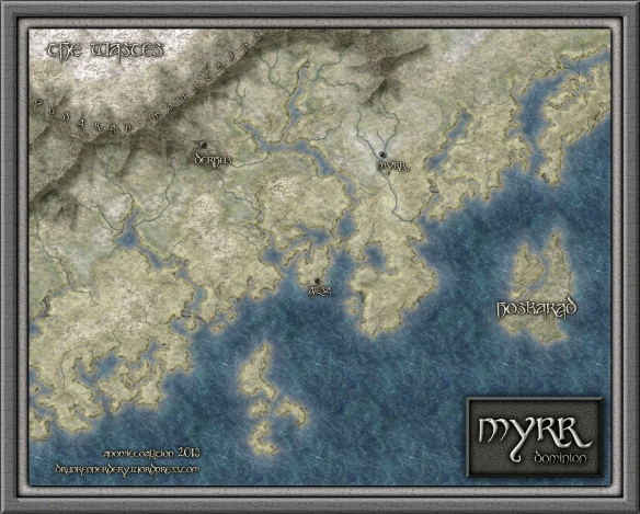
This map depicts an Orc dominated semi-arctic region of my homebrew world….more specifically, an Viking Orc society.  I drew a lot of inspiration from maps of Scandinavia, Alaska, and Iceland in creating the landmass.  It was created entirely in CC3 and features a variety of textures downloaded from the Dunjinni Forums and CGtextures.com.

Myrr Dominion

I’m calling this “tentatively done” because it really was just a side-track from my Al-Qadim campaign maps.  One of the players wants to make a viking-type character (pillage and plunder gone wrong…shipwrecked in the desert…etc…) and I thought I would oblige them by creating a part of my world where they might originate.  Although I’ve planned out some of this region, I haven’t had the time to work it all out…so much of the labeling will have to wait until I can come back to this.

So, here is the back story so far…As I develop it further, I will add more labels and what not.

The Orcs regard the caverns of the Vodgran Mountains as their ancestral homeland.  The dwarves of the region beg to differ and were successful in driving the Orcs into the inhospitable arctic desert known as the Wastes.  For centuries the Orcs have waged an unsuccessful war to reclaim the mountains.  However, recognizing the difficulty of this endeavor, the Myrr Clan has instead called for a campaign of pillage and plunder in the more fertile regions south of the mountains.  For most Orcs, giving up on their mountain home was considered sacrilege.  The Myrrs were exiled.

However, the Myrr were also successful and after many years were able to slowly but steadily claim territory that had been occupied by Humans, Dwarves, and Elves.  Each victory brought new recruits from clans that were previously opposed to the Myrr.  Although humans had traditionally enjoyed peaceful coexistence with Dwarves and Elves, the latter two could not resolve their historic differences to join forces against the Orcish campaign of pillage and plunder.  Eventually, the Elves retreated to their island sanctuary of Hosbarad…here, their defenses have held up.  The dwarves retreated to their underground mountain city of Dekhus.  Unlike the more traditional orcish clans, the Myrr have no interest in reclaiming the mountains or expending the blood and treasure required to seize this well fortified dwarven city.  All of the other villages, cities, and territories in the region have fallen under Myrr control.

The Myrr government may be described as a military oligarchy/federation.  Each conquered region becomes a part of the dominion but is locally ruled by the military leader who led the assault.  They are given relatively free rein over the territory so long as they continue to pay tribute (treasure and soldiers) to the central government in their new capital city of Myrr.  Those they conquer are allowed to repair their homes and live as second class citizens.  However, to foster expansion, the central government allows anyone (from any race or social standing) to venture out, conquer new territory, and  become governor of that territory in much the same way the Orcs do.  Competition between clans is a natural by product of this policy, but although skirmishes happen from time to time, open conflict is violently put down by the central government.  In the end, this policy has been a resounding success.  By providing a means of increasing social status, the Myrr government has incentivized and promulgated their viking culture….and given the vast wild islands and territories in the region, there is no sign of it abating.

*Gilsa is a small coastal community of fisherman where my player’s character will originate.


Leave a comment

Village of Taffarel

The “Village of Taffarel” was my entry into the Cartographer’s Guild September/October 2012 Lite Challenge.  The challenge was to create a village map which depicted a secret of some kind.

This village is situated on a series of small plateaus in a mountainous region of my Al-Qadim campaign.  Its sort of a frontier outpost that sits near the mountainous boundary between semi-arid planes of the north and brutal desert to the south (Al-Qadim proper).  It is therefore largely autonomous and informally ruled by a large extended family whose elders are the head priests of the local temple.  The villagers themselves are primarily former nomads who have settled in this area for protection from other nomadic bands and tend livestock.

This map contains two secrets (although they were not depicted explicitly). Unbeknownst to outsiders or the average villager is that this ruling family is actually a clan of Lycan (Were-Hyenas) who have been terrorizing many of the nomadic tribes and small villages in the surrounding area.  Furthermore, the local temple is a shrine to “Inalla” who is commonly known as a goddess of nature, survival and instinct, but lesser known as the patron saint of Lycans.  The high priest in this temple is the Progenitor of this Were-Hyena bloodline and the family compound to the east is the home of his clan.

The second secret is that this clan of Lycan have also entered into an alliance with a Drow community.  The details of this community and the nature of their relationship to the Lycan still needs to be developed, but it largely revolves around inciting broader unease/rebellion in the Elvish communities of Al-Qadim.  The Lycans protect a secret entrance to the Underdark that lies beneath the temple (more specially, beneath the State of Inalla in the main hall of the temple.)

The temple was made with CC3 and utilizes textures modified from CGtextures.com.  It also relies upon symbols that can be found in the CSUAC and Dunjinni forums (Special thanks to Bogie for providing the Statue of Inalla.)  The rest of the map was created in Photoshop.


Leave a comment

Lost City of Ubar

August/September 2012 Cartographer’s Guild Lite Challenge Winner!

The challenge was to create two maps on the same image which depicts something before and after an event.  The inspiration for my entry came from a documentary I had seen on the History Channel a few months before. Part of it discussed the legend of the ancient desert city of Ubar (which some believe to have been in modern day Oman.)  The basic story is that this thriving trading center in the middle of the desert eventually collapsed on itself as the Oasis depleted.  (i.e. the water cavity beneath the city which supplied the oasis eventually caved in).  When I got into mapping a few weeks later, I kept thinking about how i’d like to eventually recreate the city and adapt the story to the Al-Qadim campaign that I’m running.

My adaptation to the story can be found in the text of the map. The basic gist is that the city was destroyed (by a similar means) as revenge for the ruler’s betrayal of a Genie.

I learned a great deal about Photoshop in doing this map and really benefited from the thoughtful comments and critiques from others on the forum.  The Work-In-Progress thread can be found here.


1 Comment

Glandred’s Hollow

This map was made using Photoshop for the Cartographer’s guild July/August Lite Challenge (2012).  In the challenge you had a limited shape and color palette to work with.

The map depicts a small village lying in the shadow of a small mountain.  Inside the mountain lies a Dwarven city/mine.  The village serves as a above ground conduit for the outside world and assorted trading goods; along with providing an added level of security and home for a variety of little races (gnomes, halflings, etc.)

I arrived at the name using a Dwarf name generator program.  It translates into “the lost maiden”.  I used that name to develop a little back story and the lyric displayed in the border.

Without Hope But Undeterred,

The Maiden Awaits Her Lord’s Return,

Beyond Our Gates And In The Shadows,

Forever Known as Glandred’s Hollow.

Generations ago, a Dwarven lord went to war and never returned.  His lady was inconsolable and refused to believe he was dead.  She spent the rest of her days roaming the shadows of the mountain…and her spirit remains (to either curse or protect the village…haven’t decided yet.)


Leave a comment

Gulwen’s Church

This was another early map made with CC3.  This church is situated in the City of Ankor, but lays beyond the city walls on the northeastern part of the island.  It is maintained by Gulwen who is a member of a rebel group opposed to the Government of Sondim.  The basement serves as a safe house for freed slaves and those who oppose the government.

Gulwen’s Church

Gulwen’s Church – Basement (Safe house)


Leave a comment

Ankor Prison

This was my first real attempt to map a structure.  It was done with CC3 and utilized a variety of symbols obtained from the CSUAC and the Dunjinni forums.

The prison is situated in the City of Ankor.  It houses common criminals on the first floor and the more expensive slaves on the second floor.  The second floor also features a thieves guild hideout.