Drunken Nerdery

Cause D&D is more fun with Booze


Leave a comment

New Adventure – DN 02 – The False Prophet

Hey all – Created a new adventure that was a hit with my gaming group.  I’ve made it available for purchase at DriveThruRPG for $3.

DN 02 - The Flase Prophet 1

This adventure was designed to drive your players crazy!  A magical maze with teleporting doors and moving blocksrooms filled with deadly undead and constructs…a puzzle room with multiple traps and hazards…and all while being hunted by an Obsidian Minotaur!

3.5 Compatible Adventure for 4 PCs of levels 8-10

After a near death encounter with a Behir, the Adventuring Party will accompany a nomadic tribe to the Village of Etzal.  There they will witness a bizarre religious ceremony in which one of teh tribesmen is sacrificed to the deity Atesh.  After some investigation, the PCs will have reason to doubt the sincerity of the village’s new religious leader and this ritual he has recently initiated.  What they don’t know is that his tower is a magical maze where they will be hunted by a variety of creatures and exposed to a puzzle room where they will need to rely on their wits to avoid certain death.

2 - Village of Etzal Overview - Small 4a - Watchtower Maze Overview - Small 8 - 2nd Floor Hallway - Small

With this Purchase you get:

  • An Adventure book (25 pages) that includes:
    • Complete Stat Blocks for all creatures and GM Reference Maps as close to the description of the encounter as possible.
    • Fully developed religious mountain village (Etzal) that includes a map and descriptions of notable places and NPCs that can be used for future adventures.
    • Fully developed new Religion (Order of Atesh) practiced by nomadic tribes or other desert dwellers.
  • A Map Book (27 pages) that includes:
    • Ready to Print, scaled (5′ = 1″) letter sized, multiple page PDFs in color for all combat encounters.  No need to mess with printer settings – just print, cut the white margins, and glue/tape together so that the overlapping parts match for a seamless map.
  • Zip file contains:
    • Full sized JPGs for all encounters to use with your favorite VTT or to take to your local print shop.

Leave a comment

Desert Town Street Encounter

Hey all – Needed an encounter map for a street in a small desert town.  So I whipped this up in photoshop and made it available to buy ($1) at DriveThruRpg.  It comes with full sized .jpgs to plug into a VTT and ready to print versions in a .pdf (8 versions in all – without or without grid, labels, color/grayscale).

Cover Page for DTRPG


Leave a comment

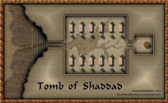
Tomb of Shaddad

This is a reproduction of a map for the Al-Qadim adventure/encounter “The Genie’s Terror” from the City of Bones sourcebook.  The basic story is that the PCs are walking along a wadi (dry desert river basin) when a storm comes (sudden storms in the desert often lead to flash floods which temporarily fill the wadis).  The storm has washed away some mud in a nearby cliff face to expose a set of steps descending into the earth.  They will soon discover that this is the tomb of a powerful Shi’ar and a dozen shadows.

The map is made with CC3 and utilizes textures from CGtextures.com and several objects from the Dunjinni forums.

Tomb of Shaddad_v2


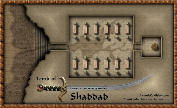
and…due to popular demand from the Profantasy forum…here’s the version with a Scimitar (modified from version found on the Dunjinni forums) incorporated into the title.  The “Cyclone of the Four Quarters” is the name of the magical scimitar utilized by an ancient Sha’ir buried within the tomb.  Obtaining it is the real prize of this encounter.

Tomb of Shaddad_v3


2 Comments

Buried Temple of Ifar (Desert Nomads Series)

This map depicts my attempt at the “Buried Temple” encounter in the old school D&D “Master of Desert Nomads” adventure series (X4).

“The Buried Temple of Ifar” (Profantasy Blog Entry)

Mapping has become one of my favorite escapes from the drudgery that is graduate school.  Whether it’s developing a mystical environment from scratch or recreating a classic adventure, I look forward to spending a few hours playing around with CC3.  Lately it’s been the latter, and I’ve found quite a few gems mining my mini-library of TSR adventures.

This particular map is a reproduction of a “Buried Temple” encounter in the “Master of the Desert Nomads” module (X4).  Our adventures leave the comforts of a desert oasis to investigate a recently unearthed buried temple – Once inside they’ll discover all manner of nefarious creatures, but should they survive, the rewards will be well worth the effort.

Scan

The most challenging aspect was trying to find a way to depict areas that are both above and below ground on the same map.  I spent a great deal of time (and got lots of great suggestions from others on the Profantasy Forums) messing with my underground section.  After creating my underground walls, I multipoly’d the area outside the walls and placed that shape on my Background sheet (which sat below my wall sheet on the list).  From there I applied a subtle edge fade inner effect so that the sand was slightly covering the wall.  I then multipoly’d the area inside my underground wall, applied my sand fill to that shape, and then added a transparency effect to that sheet.  My hope was that these two techniques would give the view the impression that this area was underground.

After that, it was just a matter of dressing my dungeon utilizing various symbols from the CSUAC and textures from CGTextures.com.  I also created a bunch of sand dune sheets (edge fade inner and glow effects) to muddy up the background.   I’d be lying if I said that I was completely satisfied with the final product, but I think its human nature to demand more of yourself.   I made a lot of mistakes with this map, but I learned even more. ..And I can’t wait for my next opportunity to start the cycle all over again.


Leave a comment

Village of Pramayama

I’m going to be updating/adapting this old D&D expert set adventure module (“Master of the Desert Nomads” and “Temple of Death”) to 3.5 for my Al-Qadim game. A lot of the story and encounters are going to be changed to fit my needs, but the nuts and bolts will remain. So, I’ll be doing a series of maps for the adventure. This is the first. I’ve loosely based it off the map provided, but changed almost everything about it. This will be the village where the PCs will begin. Its a small village that focuses on fishing, farming, and a little ranching. Its situated in the scrublands bordering the desert environment.

*Here is a new version that incorporates many of the suggestions provided by folks at the Cartographers Guild and Profantasy Forums.  As you can see, I’ve increased the number of houses and decreased their size (along with changing the overall scale).  I’ve fixed some typos in the text and added a few more labels.


Leave a comment

Palace of the Twisted King

Since my PCs are frequently roaming about the desert, I thought it would be cool to have some more complex random encounters for them while their making their way from city to city. I stumbled upon side-quest type encounter in Dungeon Magazine (#116) “Palace of the Twisted King” that seemed to suit this purpose. Although I remained pretty faithful to the original layout, I made some modifications to the original design to suit my own aesthetic.

The plan is that they would seek shelter from a vicious sand storm in this ruined way station. However, the real terror for them begins that night as a group of “Meenlocks” torment them from their secret basement tunnels.

Here is the tunnel system that runs below the ruins. Its a very tight tunnel (only a couple feet wide and tall) and at the end is a cave where the Meenlocks dwell when they aren’t torturing unsuspecting passersby.  The * mark the spot where a secret entrance can be found in the ruin map (beneath the sand).

Both of these maps were made with CC3 and utilize objects which can be found in the CSUAC and Dunjinni Forums.  I also quickly combined the two in Photoshop.


Leave a comment

Village of Taffarel

The “Village of Taffarel” was my entry into the Cartographer’s Guild September/October 2012 Lite Challenge.  The challenge was to create a village map which depicted a secret of some kind.

This village is situated on a series of small plateaus in a mountainous region of my Al-Qadim campaign.  Its sort of a frontier outpost that sits near the mountainous boundary between semi-arid planes of the north and brutal desert to the south (Al-Qadim proper).  It is therefore largely autonomous and informally ruled by a large extended family whose elders are the head priests of the local temple.  The villagers themselves are primarily former nomads who have settled in this area for protection from other nomadic bands and tend livestock.

This map contains two secrets (although they were not depicted explicitly). Unbeknownst to outsiders or the average villager is that this ruling family is actually a clan of Lycan (Were-Hyenas) who have been terrorizing many of the nomadic tribes and small villages in the surrounding area.  Furthermore, the local temple is a shrine to “Inalla” who is commonly known as a goddess of nature, survival and instinct, but lesser known as the patron saint of Lycans.  The high priest in this temple is the Progenitor of this Were-Hyena bloodline and the family compound to the east is the home of his clan.

The second secret is that this clan of Lycan have also entered into an alliance with a Drow community.  The details of this community and the nature of their relationship to the Lycan still needs to be developed, but it largely revolves around inciting broader unease/rebellion in the Elvish communities of Al-Qadim.  The Lycans protect a secret entrance to the Underdark that lies beneath the temple (more specially, beneath the State of Inalla in the main hall of the temple.)

The temple was made with CC3 and utilizes textures modified from CGtextures.com.  It also relies upon symbols that can be found in the CSUAC and Dunjinni forums (Special thanks to Bogie for providing the Statue of Inalla.)  The rest of the map was created in Photoshop.


Leave a comment

Lost City of Ubar

August/September 2012 Cartographer’s Guild Lite Challenge Winner!

The challenge was to create two maps on the same image which depicts something before and after an event.  The inspiration for my entry came from a documentary I had seen on the History Channel a few months before. Part of it discussed the legend of the ancient desert city of Ubar (which some believe to have been in modern day Oman.)  The basic story is that this thriving trading center in the middle of the desert eventually collapsed on itself as the Oasis depleted.  (i.e. the water cavity beneath the city which supplied the oasis eventually caved in).  When I got into mapping a few weeks later, I kept thinking about how i’d like to eventually recreate the city and adapt the story to the Al-Qadim campaign that I’m running.

My adaptation to the story can be found in the text of the map. The basic gist is that the city was destroyed (by a similar means) as revenge for the ruler’s betrayal of a Genie.

I learned a great deal about Photoshop in doing this map and really benefited from the thoughtful comments and critiques from others on the forum.  The Work-In-Progress thread can be found here.


Leave a comment

Desert Ravine Community

This is one of my earlier maps which depicts a small desert community overlooking a ravine and another city situated at a lower elevation.  I haven’t developed any kind of back-story or defined the locations – but I do plan on developing a  region in my world in the future where the geography is similar to this (i.e. plateaus of varying elevations in close proximity).


Made with CC3.  Cliffs were done using overlays downloaded from the Dunjinnin Forums.  Most objects can either be found there or in the CSUAC.