Drunken Nerdery

Cause D&D is more fun with Booze


1 Comment

Glandred’s Hollow

This map was made using Photoshop for the Cartographer’s guild July/August Lite Challenge (2012).  In the challenge you had a limited shape and color palette to work with.

The map depicts a small village lying in the shadow of a small mountain.  Inside the mountain lies a Dwarven city/mine.  The village serves as a above ground conduit for the outside world and assorted trading goods; along with providing an added level of security and home for a variety of little races (gnomes, halflings, etc.)

I arrived at the name using a Dwarf name generator program.  It translates into “the lost maiden”.  I used that name to develop a little back story and the lyric displayed in the border.

Without Hope But Undeterred,

The Maiden Awaits Her Lord’s Return,

Beyond Our Gates And In The Shadows,

Forever Known as Glandred’s Hollow.

Generations ago, a Dwarven lord went to war and never returned.  His lady was inconsolable and refused to believe he was dead.  She spent the rest of her days roaming the shadows of the mountain…and her spirit remains (to either curse or protect the village…haven’t decided yet.)


Leave a comment

Gulwen’s Church

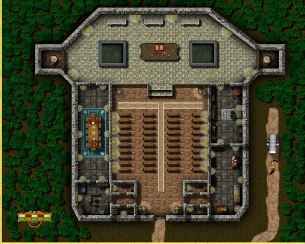
This was another early map made with CC3.  This church is situated in the City of Ankor, but lays beyond the city walls on the northeastern part of the island.  It is maintained by Gulwen who is a member of a rebel group opposed to the Government of Sondim.  The basement serves as a safe house for freed slaves and those who oppose the government.

Gulwen’s Church

Gulwen’s Church – Basement (Safe house)


Leave a comment

Ankor Prison

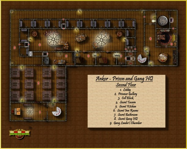
This was my first real attempt to map a structure.  It was done with CC3 and utilized a variety of symbols obtained from the CSUAC and the Dunjinni forums.

The prison is situated in the City of Ankor.  It houses common criminals on the first floor and the more expensive slaves on the second floor.  The second floor also features a thieves guild hideout.


Leave a comment

City of Ankor

This was my first attempt to make a city in CC3.  It was a good learning experience and serves its purpose…but nothing is to scale (perhaps the greatest lesson I learned after doing this city).

Ankor is a trading city/town located in the country of Sondim.  It is situated on a small island in the middle of a large river.  Its purpose was to serve as a trading post for the half-elf slaves that are being bred by the Sondim government   Upon arrival, slaves are held one of the four prisons on the island before being transported to other cites/regions.

There is a church on the northeastern tip of the island which serves as a safe house for slaves who have been liberated and rebels seeking to conduct covert operations in the city.


Leave a comment

Temple of Huron

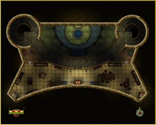
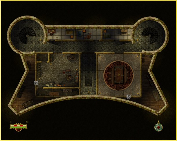
This is a temple I created for a mapping challenge at the Cartographer’s Guild.  It was my first attempt to utilize the lighting effects available from the CC3 Annual.

It is situated deep in the Herion Islands and can only be accessed via a mountain pass.  It was constructed by Elves many generations ago as a shrine to their creator god.  Brave warriors would seek it out as a rite of passage and would be blessed should they survive the journey.

Eventually, the elvish nation which maintained this temple went to war with a human clan and were eventually defeated.  The head cleric of the temple was angry that his patron god did not intervene in this war and turned to malevolent deities in a failed attempt to alter the situation.  Since then, the temple has fallen into ruin and darkness.  The cleric remains in the temple and has amassed a considerable undead following.

Ground Floor

2nd Floor

Basement – 1st Level

Basement – 2nd Level

Basement – 3rd Level


Leave a comment

Desert Ravine Community

This is one of my earlier maps which depicts a small desert community overlooking a ravine and another city situated at a lower elevation.  I haven’t developed any kind of back-story or defined the locations – but I do plan on developing a  region in my world in the future where the geography is similar to this (i.e. plateaus of varying elevations in close proximity).


Made with CC3.  Cliffs were done using overlays downloaded from the Dunjinnin Forums.  Most objects can either be found there or in the CSUAC.


Leave a comment

My World…thus far…

Haven’t thought of a clever name for the world I’ve been creating…

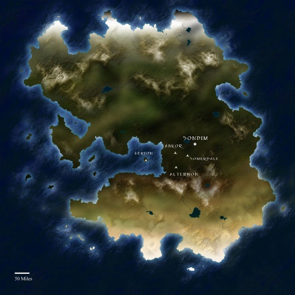
But here is a map of the continent thus far.  It was made with Photoshop by following Ascension’s tutorial.

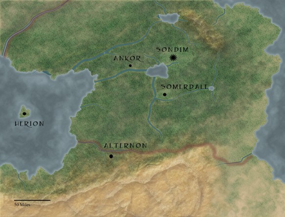
The city names labeled thus far belong to the country of “Sondim” whose boundaries roughly correspond to the locations listed above.

This is a close up regional map of “Sondim”.  It was also made in Photoshop by following Tear’s Saderan tutorial.

The Al-Qadim stuff that i’ve been mapping would presumably fit somewhere to the south of my continent in the desert region.


4 Comments

“Nine Flawed Sapphires”

This is a map derived from the “Nine Flawed Sapphires” adventure provided in the “A Dozen and One Adventures” Sourcebook (by Steven Kurtz). I tried to remain true to the original but made several modifications. The story is that this complex is serves as a warehouse/production center/hideout for someone who is illegally distributing wine (alcohol is illegal in the Al-Qadim world). The hideout is hidden behind “Sakina Falls” and can be accessed by uttering the magic words which shift the waterfall to the left. The entire place is magically illuminated (hence the reason why you will find no torches).

Since the PCs will not know the magic word, the best plan to gain entry is to ambush someone as they come out.  To facilitate that, I’ve created this rather large encounter map.

Both maps were made using CC3 and a variety of objects derived from the CSUAC or Dunjinni Forums.


Leave a comment

“The Lost Oasis”

My players have requested that I incorporate a desert flavor into the campaign and since I’m pretty new to world creation, I decided to base this on 2nd edition Al-Qadim. I plan on constructing a bunch of maps for some of the pre-made adventures for this series until I get a better grasp on designing a desert campaign of my own. I thought a good place to start was “The Last Oasis” provided by Dungeon Magazine (Issue 51). Players are hired to escort a caravan and stumble upon the “Borderland” which is a spiritual way point between the living and the dead.

This is a map of the Oasis which can be found in this “Borderland” region. I followed the basic map provided in the article pretty closely (but the original lacked detail, so I had to modify it a bit). I’m pretty sure that most of the symbols can be found in the CSUAC (buildings were constructed rather than stamped in) and the map was made with CC3. Font can be downloaded from Al-qadim.com.


I have also created a simple encounter map for use with this adventure.  Our players encounter an Obelisk and several corpses resting upon a dune.  Unfortunately for them, these corpses are not “dead”.


Leave a comment

Brightstone Keep

After a rather lengthy hiatus from the world of fantasy and roleplaying, I recently convinced a few friends to give it a try and set about constructing a world that would be interesting enough to keep their interest.  Along the way, I stumbled upon Campaign Cartographer and was amazed at the maps that people were producing with them and the possibility that it provides to even the artistically challenged (like myself).  After a short couple of week tinkering with the program and learning a great deal from the tutorials available I constructed “Brightstone Keep.”
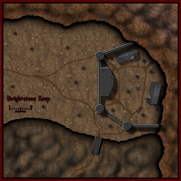
The map and its back story are loosely based on a free adventure provided by Wizards of the Coast.  The keep protects a mining operation that has been overrun by a variety of nefarious creatures.  Most (if not all) of the symbols utilized can be obtained from the CSUAC.

The first step in creating this map was to establish the geography.  I needed to depict a mountain wall running from the top left to bottom right corner (3 separate sheets and shapes) and a cliff running left to right towards the bottom of the map (1 sheet and shape).  I began by drawing a rough outline of the mountain wall and filled it with a dirt texture. (I learned that it is a good idea to draw beyond the map border on these shapes to ensure that if I applied any edge-fade effects, they wouldn’t appear on the border side of the map).  I then applied a slight blur and two black outer glow effects (One with strength of 0 above another with strength of 1).  I then created two more shapes and sheets to go above this mountain wall and utilized different dirt textures.  To these sheets, I applied a slight blur and an edge-fade-inner effect.  Depicting the cliff was a bit simpler – here I just reused the dirt texture from the background but constructed a separate shape on a separate sheet and applied a similar setting as that use on the first mountain wall sheet (but with an inner glow).  The final step was to add some hill overlay transparencies to add some character to the terrain.  I applied these symbols on a separate sheet and varied the size/orientation to achieve the desired effect.

In constructing the walls of the keep, I created 4 sets of sheets and shapes.  I began by drawing some solid gray lines (width of 6 – adjust to scale) to create the outer wall.  I then applied a texture sheet effect (stone texture of your choosing, Intensity 1, size 15); on top of that a black outer glow (strength 1, blur 2); a wall shadow (length 15, opacity 65, blur 5); and finally a bevel (length 1.5, strength 35, and fade 1).  I next wanted to create a walkway for that wall.  I copied the image to a new sheet and reduced the width to 3.  I then applied a texture sheet effect (with a different stone texture but same settings) and an inner black glow (strength 1, blur 2).  I followed the same procedure to construct the towers/ramp and placed those shapes and sheets on top of the wall. (The ramp actually required that I draw in a black shadow on the right side to give it some dimensionality.)

The last step was to draw in some roads and tracks.  I laid down a road (added a texture, blur, and edge-fade-inner sheet effect) and then drew in the tracks according to the instructions provided in the Jon Roberts Special Issue of the Annual – http://sub.profantasy.com/2011/june11.html).  From there it was just a matter of placing some vegetation, rocks, buildings, and text to complete my map.

I had a great time making this map and was amazed at how easy it was once I familiarized myself with the program (the video tutorials and assorted blog entries are invaluable.)  I just hope my friends enjoy playing with this map as much as I enjoyed making it.

Tower – Ground Level

Tower – 2nd Floor

Tower – Roof
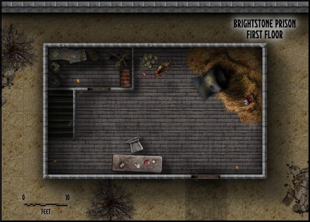
Prison – 1st Floor
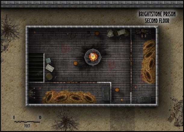
Prison – 2nd Floor

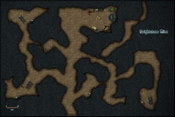
Mine/Cave/Mountain Pass to Temple of Huron